Save Passamaquoddy Bay
Alliance to Protect the Quoddy Region
US
Canada
Passamaquoddy

|
Loading
|
"For much of the state of Maine, the environment is the economy" |
|
|
|
|
|
|
|
|
Zones of Concern — Thermal Hazard Zones
for the proposed
Quoddy Bay LNG
&
Downeast LNG
projects
Obtained from the US Coast Guard
on 2007 June 4 via
the US Freedom of Information Act
FOIA Request | Zones of Concern | 1-mile Thermal Hazard Zone | Graphics
Freedom of Information Act (FOIA) Request
On 2007 February 7, Save Passamaquoddy Bay filed a Freedom of Information Act (FOIA) request with the US Coast Guard (USCG) for the graphics prepared by Quoddy Bay LNG and Downeast LNG (or their contractors) showing the Thermal Hazard Zones that would accompany LNG ships transiting to the proposed LNG terminals in Passamaquoddy Bay. On 2007 June 4, we photographed the graphics at the USCG South Portland headquarters. The photographs are available to the public in multiple sizes, below.
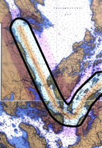
The graphics each show the three "Zones of Concern," the second of which is virtually the 1-mile Thermal Hazard Zone.
Zones of Concern
Read the US Coast Guard Captain of the Port, CAPT Stephen Garrity's explanation of Zones of Concern.
The following document citations provide further explanation about "Zones of Concern."
"…a critical part of the WSA [Waterway Suitability Assessment conducted by the US Coast Guard] is an analysis of an LNG spill on the waterway and the thermal effects from a resulting pool fire. The analysis includes the application of the hazard distances and zones of concern established by the spill consequence models described in the 2004 Sandia National Labs Report." [Bold and red emphasis added.] "The Coast Guard expects applicants to analyze and graphically represent the zones of concern and their intersections with populations, infrastructure, assets, and waterways, as well as commercial, residential, industrial, and environmentally sensitive areas.
"These representations must apply appropriate models, such as those set forth by the Sandia report, to identify areas where a release of LNG would have the worst consequences." [Bold red emphasis added.]
"…approximate hazard zones seem to exist between 0 – 500 m, 500 – 1600 m, and over 1600 m, and were used to develop guidance on managing risks for LNG spills."
Zone 1
"…high thermal hazards from a fire are expected to occur within approximately 250 – 500 m from the origin of the spill, depending on the size of the spill. Major injuries and significant structural damage are possible in this zone."
Zone 2
"In this zone, risk management strategies for LNG operations should focus on approaches dealing with both vapor dispersion and fire hazards."
Zone 3
"Risk management strategies should concentrate on incident management and emergency response measures that are focused on dealing with vapor cloud dispersion. Measures should ensure areas of refuge are available, and community education programs should be implemented to ensure that persons know what to do in the unlikely event of a vapor cloud."
"In general, the distance to low thermal hazard levels, about 5 kW/m 2 is about 600-750 m for accidental spills and approximately 1600 m for intentional spills. For a very large, cascading spill, high hazard zones could approach 2000 m."
"If the cloud is ignited at a significant distance from the spill, the thermal hazard zones can be extended significantly. The thermal radiation from the ignition of a vapor cloud can be very high within the ignited cloud and, therefore, particularly hazardous to people."
[Bold red emphasis added.]
— "Guidance on Risk Analysis and Safety Implications of a Large Liquefied Natural Gas (LNG) Spill Over Water," (the Sandia Report 2004), PDF.
- Zone of Concern 1 (innermost zone)
This zone extends 500 meters (1,640 feet, approx. 1/3 mile) from the ship. This area would be the most devastated by an LNG spill and pool fire. A pool fire within this zone would be intensely hot.
- Zone of Concern 2 — 2nd-degree burns within 30 seconds
This zone is 1,600 meters (nearly 1 mile*) from the ship.
This distance could result in 2nd-degree burns to unprotected skin within 30 seconds. Asphyxiation, cryogenic (freezing) burns, fires, and confined-gas explosions are potential hazards in this zone. The 1-mile Thermal Hazard Zone is described by the Government Accountability Office (GAO) 2007 Study on LNG for Congress.
* 1,600 meters = 5,249 feet. 1 mile = 5,280 feet. A bold black outline surrounds Zone 2 in the graphics below.
- Zone of Concern 3
Zones 3 is 3,500 meters (11,482.94 feet, approx. 2-1/10 mile) from the ship. This Zone includes areas that could be affected by a drifting LNG vapor cloud resulting from an LNG spill on water that did not ignite at the spill source. Potential hazards in this zone include fire, asphyxiation, confined-gas explosion, and burns.
The documents below were submitted to the US Coast Guard by the project developers, and show the three Zones of Concern.
1-mile Thermal Hazard Zone
Zone 2 extends to 1,600 meters from the ship, which is just 31 feet shy of one mile. At that distance, skin exposed to an LNG pool fire could receive 2nd-degree burns within 30 seconds.
Graphics of the Zones of Concern including the 1-mile Thermal Hazard Zone
For emphasis, we added a bold black border around the 1600 meter/1-mile Thermal Hazard Zone. Color has been enhanced. (Unenhanced photographs of the graphics, without the bold black borders, are also available.)
|

Original Photograph (large)
Original Photograph, cropped down to just the graphic; no color enhancement. |
Original Photograph (large)
Original Photograph, cropped down to just the graphic; no color enhancement. |


Top
Add our banner to your webpage: Read about the effort to Fix FERC: ![]()